

|
Biondo Biondi's Home |
|---|
Images obtained from seismic data are the main source of information on the structural and stratigraphic complexities in the Earth's subsurface. My students and I devise new algorithms to improve the imaging of reflection seismic data to uncover what is hidden below the surface. Images are constructed by processing the seismic wavefields recorded at the surface and generated by either active-source experiments (reflection data), or by far-away earthquakes (teleseismic data). The high-resolution and fidelity of 3-D reflection-seismic images enables oil companies to drill with high accuracy for hydrocarbon reservoirs that are buried under 2 kilometers of water and up to 15 kilometers of sediments and hard rock.
To achieve this technological feat the recorded data must be processed employing advanced mathematical algorithms that harness the power of huge computational resources. In my group we process field data on our parallel cluster running several hundreds of processors to learn about "real world" problems and to demonstrate the advantages of our algorithms. The two images below display some of our data processing results. They illustrate the effects of imaging on recorded seismic data and how it greatly improves the resolution and interpretability of the data.

|
| 3-D seismic data (zero offset). |
|
| 3-D seismic image. |
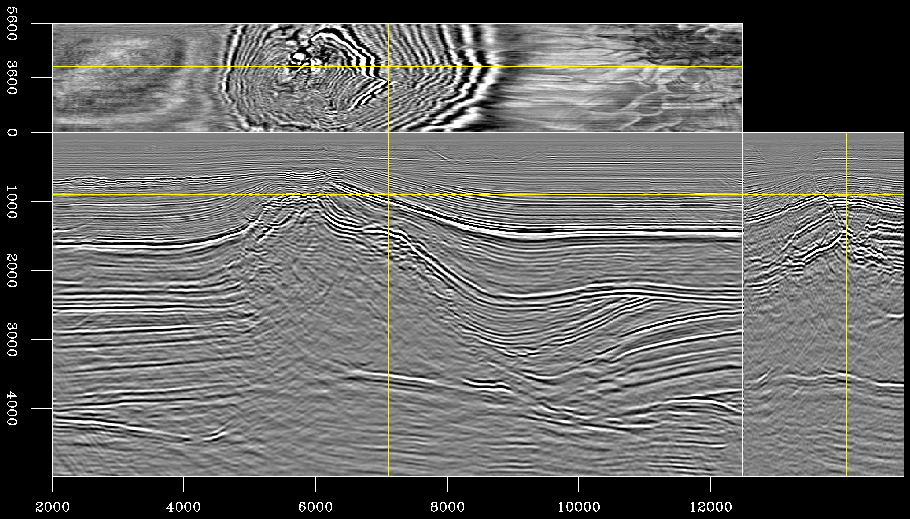
The image on the left displays a 3-D seismic data set (to be precise, a zero-offset data set) recorded in the North Sea. The figure shows the data after a fair amount of preprocessing but before the imaging step is applied. Each of the three panels in the figure shows a slice cut through the data cube along a plane orthogonal to one of the coordinate axes. These slices are taken at the location marked by the yellow lines superimposed onto the image. The vertical axis is recording time, and the horizontal axes are the physical horizontal axes corresponding to the location of the recording instruments. The data contain several coherent events, but the geological structure is "hiding" behind the unfocused diffraction patterns.
The image on the right shows the results of imaging the data set on the left using 3-D wave-equation depth migration. The vertical axis of the image is depth, instead of time. A more crucial difference is that the subsurface geology (in this case a salt diapir piercing through layers of clastic rocks and a chalk layer) is now revealed and can be easily interpreted. The large-scale structural features are imaged as sharp reflectors at their positions in the physical space. Furthermore, the subtle depositional patterns visible in the horizontal slices (time and depth slices) come into focus and provide us with an insight on the formations' depositional history.