


Figure 7 shows a day's worth of data![[*]](http://sepwww.stanford.edu/latex2html/foot_motif.gif) collected at sea by SeaBeam,
an apparatus for measuring water depth both
directly under a ship, and somewhat off to the sides of the ship's track.
The data is measurements of depth h(x,y) at miscellaneous locations
in the (x,y)-plane.
collected at sea by SeaBeam,
an apparatus for measuring water depth both
directly under a ship, and somewhat off to the sides of the ship's track.
The data is measurements of depth h(x,y) at miscellaneous locations
in the (x,y)-plane.
|
seabin90
Figure 7 Depth of the ocean under ship tracks. | 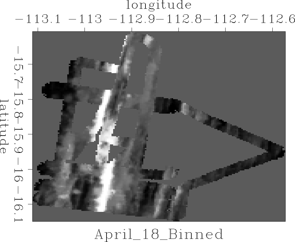 |


The locations are scattered about,
according to various aspects
of the ship's navigation and the geometry of the SeaBeam sonic antenna.
Figure 7 was made by
binning with bin2() ![[*]](http://sepwww.stanford.edu/latex2html/cross_ref_motif.gif) and equation ().
The spatial spectra of the noise in the data
could be estimated where tracks cross over themselves.
More interesting are the empty mesh locations where no data is recorded.
Here I left empty locations
with a background value equal to the mean depth
and equation ().
The spatial spectra of the noise in the data
could be estimated where tracks cross over themselves.
More interesting are the empty mesh locations where no data is recorded.
Here I left empty locations
with a background value equal to the mean depth ![]() .After you study the water-depth map for a while,
you come to realize that at many locations,
your human intuition suggests
some obvious extensions of the ocean floor ridges (which are white)
and we seek mathematical methods to guess what humans can guess,
namely,
a background depth
.After you study the water-depth map for a while,
you come to realize that at many locations,
your human intuition suggests
some obvious extensions of the ocean floor ridges (which are white)
and we seek mathematical methods to guess what humans can guess,
namely,
a background depth ![]() more plausible than
more plausible than ![]() .Theoretically this amounts to finding and using the model spectrum.
What we actually do is use a Prediction Error Filter (PEF)
to fill in the missing data.
Supposing the PEF to be the Laplacian operator
.Theoretically this amounts to finding and using the model spectrum.
What we actually do is use a Prediction Error Filter (PEF)
to fill in the missing data.
Supposing the PEF to be the Laplacian operator ![]() and using module mis2
led to the result in Figure 8.
and using module mis2
led to the result in Figure 8.
|
sealap90
Figure 8 Depth of the ocean under ship tracks interpolated by minimizing the energy of the Laplacian of the water depth. |  |
The problem we see with the Laplacian operator as an interpolator
is that it smears things uniformly in all directions.
From Figure 8 we see that we need an anisotropic interpolation
oriented along the regional trends.
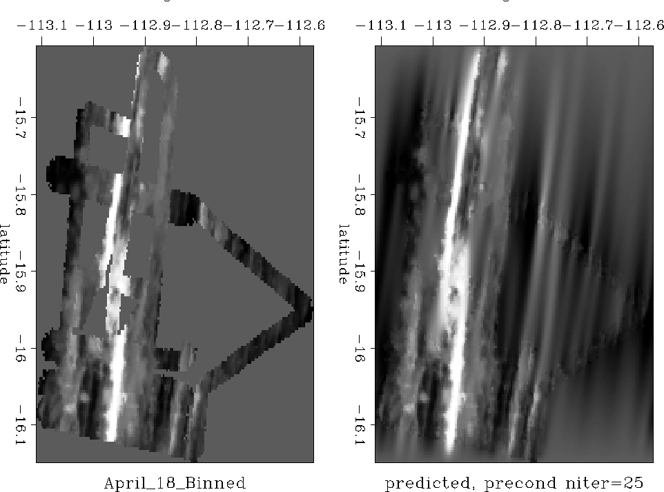
To find a better PEF
we apply module pef
to the image of Figure 7.
After binning the data and finding this PEF,
we do a second stage of linear-least-squares optimization
with mis2 , as we did for Figure
6,
and
we obtain the pleasing result in Figure 9.
 |