Next: DISCUSSION
Up: NUMERICAL RESULTS
Previous: Imaging the location of
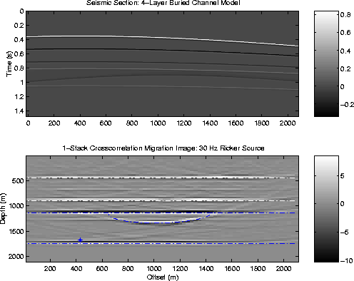
A single impulsive source is located somewhere in depth,
and the synthetic data generated in a 4-layer channel model
are shown at the top of Figure 9.
The interface boundaries are delineated by the dash-dot lines in
the bottom figure, including the semi-circle river channel
along the third interface.
Using the migration operator for ghost reflections given
by equation 6,
the data are migrated to
give the image at the bottom of Figure 9.
Note, the source location was unknown,
represented by the star symbol in the left bottom
part of the migration image.
It might be surprising that the
single source generates enough data so that the model is almost
entirely imaged.
Part of the reason
for this is that the ghost reflections
illuminate a much greater part of the
medium (for a fixed recording array) than primary reflections
alone. Each point on the free surface acts as a virtual source.
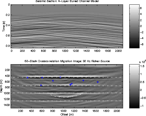
Finally, ten point sources
are buried at intermediate depths and their
emissions are recorded on the surface. Each source
is governed by a distinct random time series.
Applying the migration
operator for free-surface reflections [equation (6)]
to the data shown at the top of Figure 10
yields the result shown in the bottom figure. Fifty
one-second records were migrated and stacked
with one one another, and show that the sand
channel boundary is well imaged.
f10
Figure 9 Similar to Figure 7 except
now a a 4-layer sand channel model is imaged using one
buried source. The source time history
is a 30-Hz Ricker
wavelet.
 f12a
f12a
Figure 10 Similar to previous figure except
there are now ten buried point sources
scattered about at intermediate depths. Each source
is governed by a distinct random
time series.
Next: DISCUSSION
Up: NUMERICAL RESULTS
Previous: Imaging the location of
Stanford Exploration Project
9/5/2000