


| |
(23) |
| (24) |
 |
![[*]](http://sepwww.stanford.edu/latex2html/movie.gif)


Figure ![[*]](http://sepwww.stanford.edu/latex2html/cross_ref_motif.gif) displays
displays ![]() estimated
in a least-squares sense on the left and in a
estimated
in a least-squares sense on the left and in a ![]() sense on the right
(equation (23) with a small
sense on the right
(equation (23) with a small ![]() ).
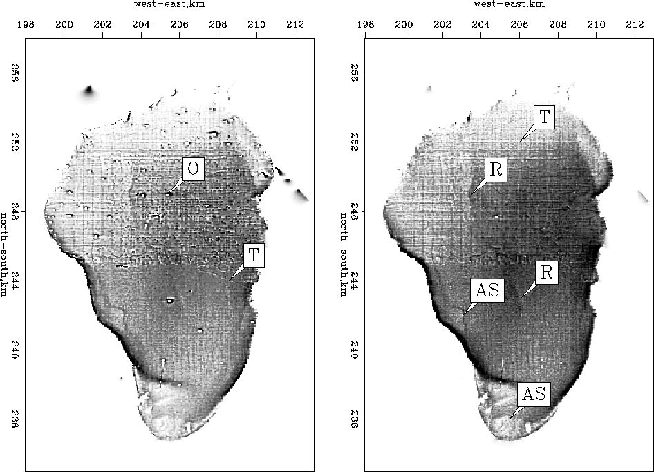
Most of the glitches are no longer visible.
One obvious glitch remains near (x,y)=(205,238).
Evidently a north-south track has a long sequence of biased measurements
that our
).
Most of the glitches are no longer visible.
One obvious glitch remains near (x,y)=(205,238).
Evidently a north-south track has a long sequence of biased measurements
that our ![]() cannot overcome.
Some ancient shorelines in the western and southern parts of the Sea of
Galilee are now easier to identify (shown as AS).
We also start to see a valley in the middle of the lake (shown as R).
Data outside the lake (navigation errors) have been mostly removed.
Data acquisition tracks (mostly north-south lines and east-west lines,
one of which is marked with a T)
are even more visible after the suppression of the outliers.
cannot overcome.
Some ancient shorelines in the western and southern parts of the Sea of
Galilee are now easier to identify (shown as AS).
We also start to see a valley in the middle of the lake (shown as R).
Data outside the lake (navigation errors) have been mostly removed.
Data acquisition tracks (mostly north-south lines and east-west lines,
one of which is marked with a T)
are even more visible after the suppression of the outliers.
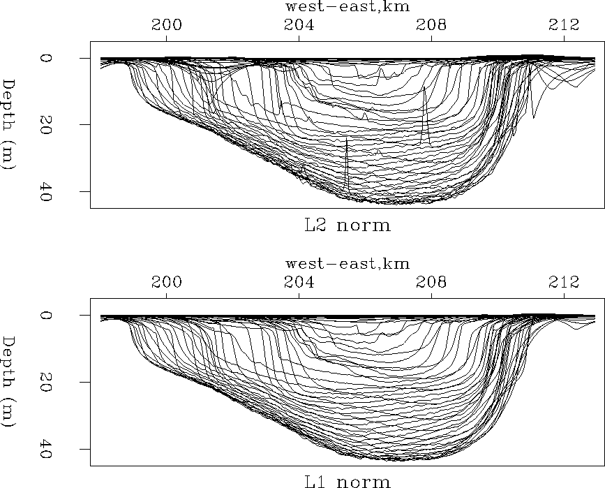 |
Figure
shows the bottom of the Sea of Galilee (![]() )with
)with ![]() (top) fitting and
(top) fitting and ![]() (bottom) fitting.
Each line represents one east-west transect,
transects at half-kilometer intervals on the north-south axis.
The
(bottom) fitting.
Each line represents one east-west transect,
transects at half-kilometer intervals on the north-south axis.
The ![]() result is a nice improvement over the
result is a nice improvement over the ![]() maps.
The glitches inside and outside the lake have mostly disappeared.
Also, the
maps.
The glitches inside and outside the lake have mostly disappeared.
Also, the ![]() norm gives positive depths everywhere.
Although not visible everywhere in all the figures,
topography is produced outside the lake.
Indeed, the effect of regularization is to produce synthetic topography,
a natural continuation of the lake floor surface.
norm gives positive depths everywhere.
Although not visible everywhere in all the figures,
topography is produced outside the lake.
Indeed, the effect of regularization is to produce synthetic topography,
a natural continuation of the lake floor surface.
We are now halfway to a noise-free image.
Figure shows that
vessel tracks overwhelm possible fine scale details.
Next we investigate a strategy based on the idea that
the inconsistency between tracks comes mainly
from different human and seasonal conditions during the data acquisition.
Since we have no records of the weather and the time
of the year the data were acquired
we presume that the depth differences between different acquisition tracks
must be small and relatively smooth along the super track.