Next: Conclusions
Up: Sava: Residual migration
Previous: Synthetic examples
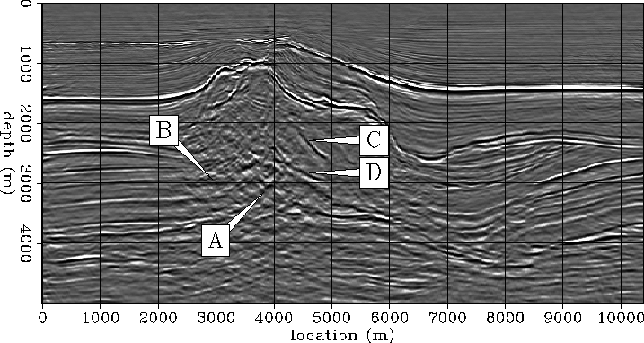
The North Sea dataset used in this paper has been previously discussed by Vaillant and Sava (1999). Figure 5 shows a 2-D slice out of the image-cube obtained by common-azimuth migration Biondi and Palacharla (1996). Without going into many details, we can observe that many of the important features of the image have been well resolved, especially away from the salt. However, there still are some regions in the image insufficiently clarified, as labeled in Figure 5:
- 1.
- (A) Where is the salt overhang flank?
- 2.
- (B) How do the sediments terminate against the salt?
- 3.
- (C)(D) What is this?
saltreal.problem
Figure 5 Seismic image for the North Sea data. Major questions still unanswered are  Where is the salt overhang flank?
  How do the sediments terminate against the salt?
 What is this?


saltreal.zoom
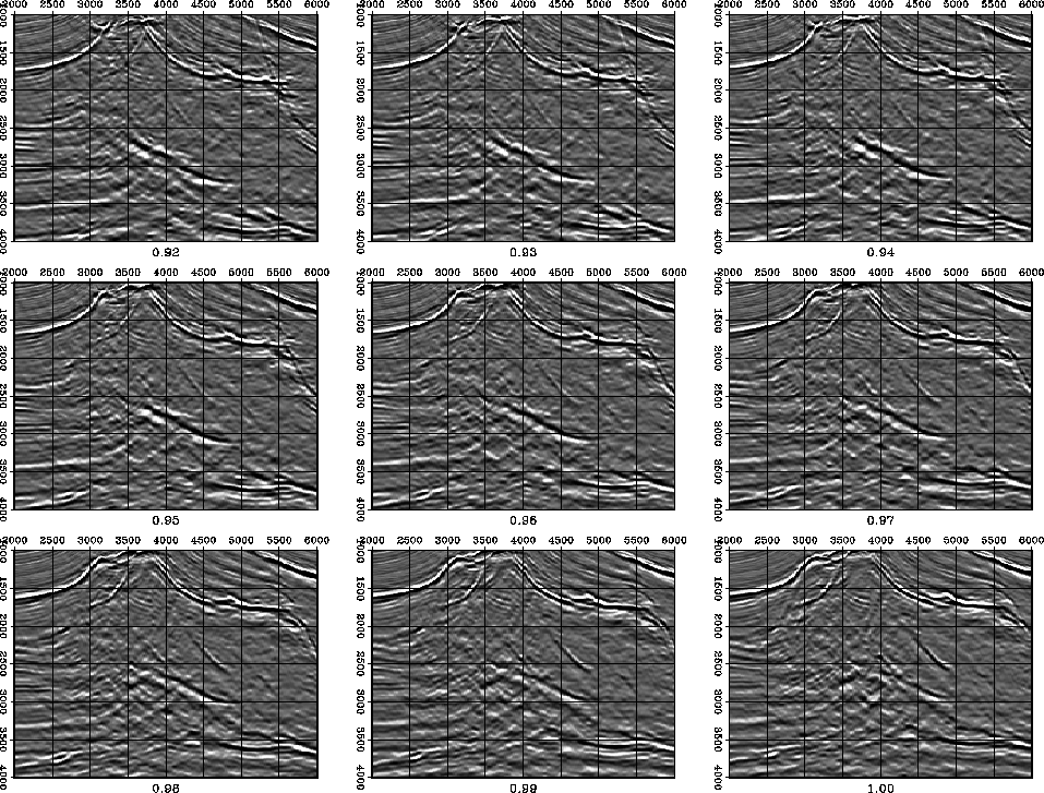
Figure 6 Zoom over the area of major blur. The goal of the residual migration is to shed as much light as possible over the region encircled with question marks.
|
| 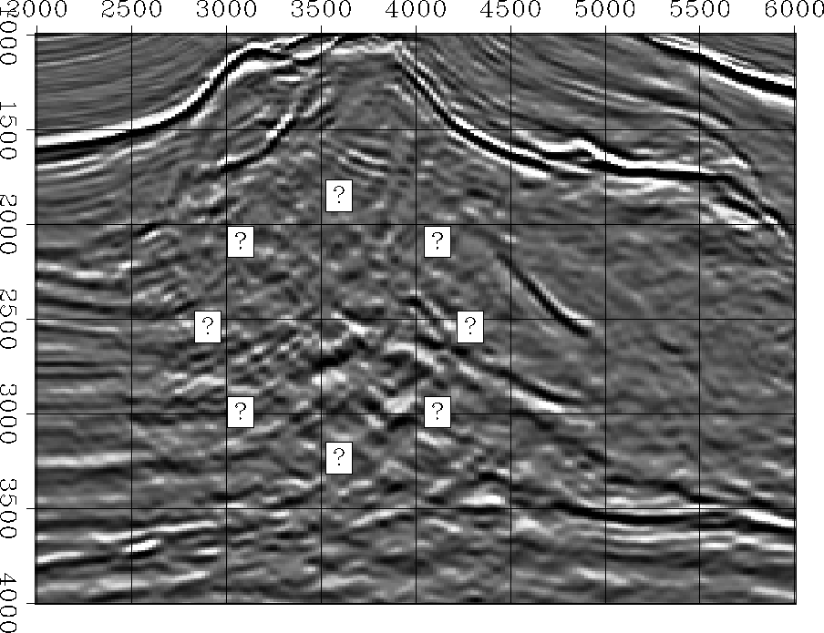 |
Essentially, an important area of the image, close to the overhang, remains under severe blur caused by the salt body. This area, encircled with question marks in Figure 6, is the focus for the residual migration processing. Two hypotheses can be made about the cause of the blur:
- it is caused by inaccuracies of the imaging algorithm, a hypothesis that is analyzed elsewhere Vaillant and Calandra (2000);
- the velocity map around the salt body is not correct, a hypothesis which is the focus of this paper.
saltreal.storm
Figure 7 Residual migration results. Each panel represent the image corresponding to different values of the parameter  , ranging from 0.92 to 1.00. The salt flank is significantly better imaged at lower values of , that is, at velocity values higher than those of the original model.
Since in this case we are analyzing a real dataset, we do not know what the correct velocity ratio ( ) is to which we would like to residually migrate. Most likely, in fact, there is no one velocity ratio that would solve the problem over the entire seismic image. What we need to do then is run residual migration for a range of velocity ratios and analyze what changes have occurred. In the end, we should either select one image which answers our questions, or interpolate an optimal image.
Figure 7 shows how the target image is changed when the parameter varies from 0.90 to 1.00. A value of  indicates that we residually migrate the image with a higher velocity than the original. It is apparent that the overhang salt flank is significantly better imaged at higher velocities compared to the reference image. Also, many of the layers in the image continue under the salt, and therefore become much easier to interpret.
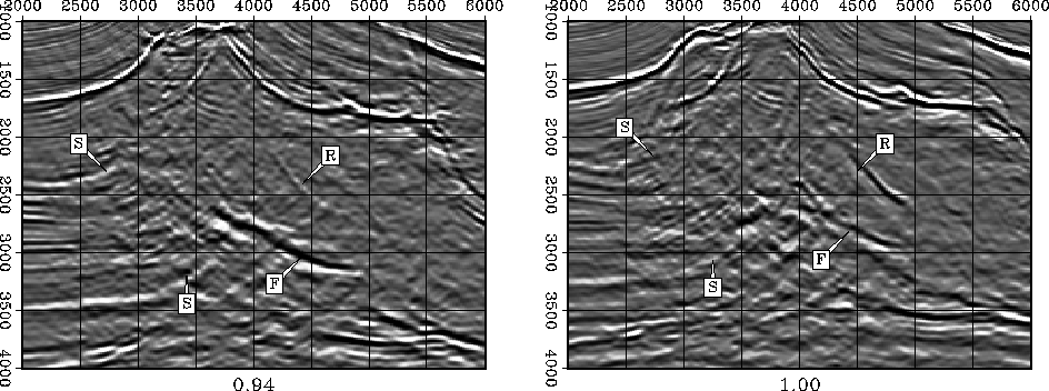
Figure 8 represents a face-to-face comparison of the original image (left panel) and a cleaner image obtained with residual migration (right panel), which enables us to answer some of the questions posed at the beginning of the discussion:
- 1.
- The salt flank (F) is more continuous and extends significantly more towards the surface. It is also more energetic, and positioned lower in the image. Since this reflector is imaged mostly with the salt velocity, we can conclude that the salt velocity is not high enough in the original model and therefore needs to be increased to achieve better imaging.
- 2.
- The reflector (R), previously imaged inside the salt, appears much fainter, perhaps simply indicating that this event is merely an artifact or a salt internal multiple.
- 3.
- The sediments below the salt S are significantly cleaner. What is practically not interpretable in the original image becomes much cleaner and makes a lot more geological sense. We can, in fact, trace how the sediments bend against the salt body.
saltreal.face2face
Figure 8 A face-to-face comparison of the original seismic image (left) and an image obtained by residual migration with the ratio  (right).
The downside of selecting only an image corresponding to a constant parameter over the entire map is that the image degrades in the regions that do not require an increase in velocity, or that may only require a smaller increase. A good example is the upper part of the salt, which appears slightly over-migrated and defocused in the residual migration panel (Figure 8, left) with respect to the original image (Figure 8, right).
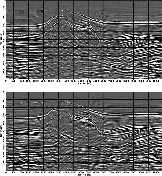
A reasonable solution to this problem is to pick different ratios at every location in the images in Figure 7. The interpolation aim is to preserve the original image in the regions where it is correct and to bring into the picture the regions that show improvement after residual migration. Figure 9 shows the result of optimal picking:
- The top part of the salt, between the horizontal locations 2500 and 3500 m, where the remaining diffraction in the original image is much better collapsed at a higher velocity (
 ).
).
- The overhang salt flank and the sediments underneath are much cleaner after residual migration than in the original. This situation also corresponds to a higher velocity ().
saltreal.comparison
Figure 9 Comparison between the images before and after residual migration. The top panel is the image obtained with common-azimuth migration on the original velocity model. It shows incomplete focusing in the upper part of the salt and blurred salt overhang. The bottom panel is the image after residual migration, and shows a collapsed diffraction at the top of the salt, and much better imaged salt overhang and under-salt sediments.
Next: Conclusions
Up: Sava: Residual migration
Previous: Synthetic examples
Stanford Exploration Project
4/27/2000